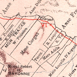
I was fortunate enough to stumble upon this old map in a second hand bookshop in England back in 2004. It is a detailed map of the Seychelles island of Mahé created in 1900 for the Seychelles Government, and interestingly shows all of the principal landowners of that time. What struck me then, as it does now, is the level of detail it contains. The original map is quite large, but I have had it digitally scanned at high-resoluion in order to display it on this website.
It was always my intention to share this beautiful map; it seemed a shame to keep such an interesting bit of Seychelles history hidden away. So after many years of procrastination I have finally got around to creating this site in order to showcase the map in all its splendid detail, in the hope that researchers, or in fact anyone with a passing interest in Indian Ocean history or cartography can explore and enjoy. I do so not for profit - but to simply share a fascinating piece of history.
I hope you enjoy it…